THE SCUBA SHOP |
|
|
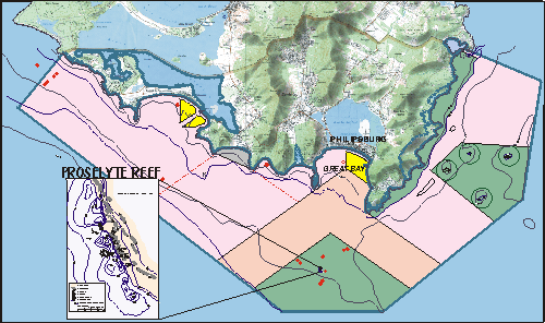
ST. MAARTEN MARINE PARK ZONING

The St. Maarten Marine Park is managed by the St. Maarten Nature Foundation. As yet the island legislation giving the park legal status is not in place, but it is expected to be passed in 2000. The Marine Park will then encompass the entire coast of St. Maarten. Different zones will provide for different uses.
ZONES OF THE MARINE PARK
CONSERVATION ZONE
(Green):
Conservation areas aim at preserving natural values by excluding all potentially damaging
activities. Conservation zones have been defined because of their significant natural
values such as the presence of unspoiled coral reefs and their function as nursery areas
for many marine animal species. Fish sanctuaries, lobster/conch and fishing areas fall
under the conservation zone.
INDUSTRIAL ZONE (Grey):
Industrial activities, including oil transshipment, cargo transport, takes place in the
general direction of Cole Bay and the Great Bay Harbor. Because of the specific risk
factors it is important to designate a separate zone for industrial use.
 |
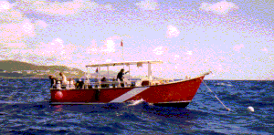
Dive
boat moored at one of the moorings |
ANCHOR ZONE (Yellow):
Anchoring causes damage to seagrass beds and coral formations. Yachts, cruise ships and
other vessels have been anchoring in an unregulated fashion for years because there are
insufficient suitable alternatives (moorings, marinas). As long as this is the case, it is
best to concentrate anchoring zones where the least damage to natural values will be
inflicted.
Since moorings cause less damage, a sufficient number of moorings will be placed to diminish and eventually eliminate anchoring completely.
TRAFFIC ZONE/SHIPPING LANES (Light
Orange):
A traffic zone is defined particularly for the large cruise ships that frequent Great
Bay. Some large cruise ships have a draft that exceeds 8 meters. Some important reef
formations, such as those outside of Great Bay can be found at relatively shallow depths.
The traffic zone serves for safety reasons, preventing cruise ships from navigating close
to hazardous reefs and dive sites. Also this zone can serve as a stand-by area for cruise
chips awaiting pilot-assistance.
In addition, shipping lanes to Cole Bay are indicated for freighters and tankers. These vessels have a draught of up to 5 meters. A reason to indicate shipping lanes for industrial purpose is (besides safety aspects) to decrease the risk of coastal pollution, e.g. oil spills. The shipping lanes converge to the coast so that as little as possible of the coastline is exposed to the risk of ship traffic.
OTHER PARK AREAS (Pink):
This is a zone where general management regulations apply.
Sint
Maarten Nature Foundation |
MORE INFORMATION |
The Sint
Maarten Nature Foundation & Marine Park
The Marine Park | The Nature Foundation | Park Zoning
Sectie Milieu en Natuur Departement van
Volksgezondheid en Milieuhygiene
(Official Site of The St. Maarten Nature Foundation - English / Dutch)
MARINE PARK ARTICLES and UPDATES |
Rescuing a
Green Sea Turtle - June 22, 2000
On June 21st, 2000 on a weekly patrol, the staff of the Marine Park
(Nature Foundation of Sint Maarten) encountered a Green Turtle (Chelonia mydas) floating
on a large tar/oil spill close to Proselyte Reef........
Update to:
Rescuing a Green Sea Turtle - July 20, 2000
I just wanted to let you
know.... rescued Green turtle sited....
Global
and Local Seagrasses Threatened - April 6, 2000
It is difficult to emphasize how important seagrasses are to the marine
environment.......
Reef Monitor
Update